
Report on the NOWPAP/PICES/WESTPAC Joint Training Course on Remote Sensing Data Analysis
8-12 October 2011 at Vladivostok, Russia
Introduction
The NOWPAP/PICES/WESTPAC joint training course on remote sensing data analysis was organized by the NOWPAP Special Monitoring & Coastal Environmental Assessment Regional Activity Centre (CEARAC), the North Pacific Marine Science Organization (PICES) and IOC Sub-Commission for the Western Pacific (WESTPAC) at Far Eastern Federal University (FEFU) in Vladivostok, Russia on 8-12 October 2011.
The training course was conducted for 22 selected trainees, including postgraduate students, professional researchers and local government officers working in the field of marine sciences, from China, Japan, Korea, Russia, India, Indonesia and the Philippines. 11 lecturers from the NOWPAP countries (China, Japan, Korea and Russia) and Germany and USA delivered lectures on remote sensing applications for monitoring and assessment of the marine and coastal environment in the Northwest Pacific Region.
Objectives
To provide opportunities for students, young researchers and coastal managers to obtain useful skills and knowledge to utilize remote sensing data to monitor and assess the coastal and marine environment
Date and Venue
The date and venue of this training course were as follows:
- Date; October 8 to 12, 2011
- Venue; Far Eastern Federal University, Vladivostok, Russia
Organization Structures
The training course was operated under the following organization structures:
- Organizer:
Special Monitoring & Coastal Environment Assessment Regional Activity Centre (CEARAC)
North Pacific Marine Science Organization (PICES)
IOC Sub-Commission for the Western Pacific (WESTPAC)
- Co-organizers and local host institutions:
V.I. Il’ichev Pacific Oceanological Institute (POI), Far Eastern Branch of the Russian Academy of Sciences
Far Eastern Federal University (FEFU)
- Supporters:
International Ocean Colour Coordinating Group (IOCCG)
22 trainees were selected out of 58 applicants by screening by the Organizing Committee consisting of experts in CEARAC, PICES and WESTPAC, based on the contents of submitted application.
Course Fee
Training course was provided for free of charge.
Course Program
|
Day |
Time |
Program |
Lecturers |
|
Oct 8 |
9:00-9:20 |
Welcome address |
POI representative CEARAC Representative |
|
9:20-10:50 |
Introduction to Satellite Oceanography (L) |
Dr. Leonid Mitnik |
|
|
11:00-12:30 |
Introduction and recent progress in ocean color remote sensing part I(L) |
Dr. Roland Doerffer |
|
|
13:30-15:00 |
Introduction and recent progress in ocean color remote sensing part II(L)
|
Dr. Roland Doerffer |
|
|
15:15-16:00 |
Global Ocean Observing System and availability of oceanographic data in the Northwestern Pacific |
Dr. Vyacheslav Lobanov
|
|
|
16:00-17:00 |
Satellite Ocean Color: Challenges & the Software
|
Dr. Mati Kahru |
|
|
Oct 9 |
9:00-10:30 |
Remote Sensing of Harmful Algal Blooms (L) |
Dr. Raphael Kudela |
|
10:45-12:15 |
Primary Productivity (L) |
Dr. Joji Ishizaka and Dr. Raphael Kudela |
|
|
13:30-15:00 |
Introduction into MERIS data |
Dr. Roland Doerffer |
|
|
15:00-17:00 |
Visualization and verification of ocean colour satellite data (H) |
Dr. Mati Kahru
|
|
|
Oct 10 |
9:00-10:30 |
Eutrophication Satellite based monitoring of marine and coastal environment of the Northwest Pacific |
Dr. Joji Ishizaka |
|
10:45-12:15 |
Introduction of GOCI status and validation activities (L) |
Dr. Yu-Hwan Ahn
|
|
|
13:30-17:00 |
Time series analysis of ocean colour data and detection of change (H) |
Dr. Mati Kahru |
|
|
Oct 11 |
9:00-10:00 |
Introduction to radiometric calibration of satellite solar reflective bands (L) |
Dr. Sung Ling
|
|
10:00-10:30 |
Landsat |
Dr. Leonid Mitnik |
|
|
10:30-12:15 |
Utilization of SAR and optical images/data for monitoring of the coastal environment
|
Dr. Natalia Evtushenko |
|
|
13:30-17:00 |
Analysis of Landsat images (H) |
Dr. Vyacheslav Dubina |
|
|
Oct 12 |
9:00-10:30 |
Monitoring of oil pollution with the use of satellite imagery (L) |
Dr. Leonid MITNIK
|
|
10:50-12:15 |
Ocean Remote Sensing Project of Coastal Habitat Mapping (L) |
Dr. Teruhisa Komatsu
|
|
|
13:00-17:30 |
Assignment for all trainees (H) |
– |
|
|
17:00-17:30 |
Closing |
|
(L) Lecture
(H) Hands-on computer excise
Training Scenery
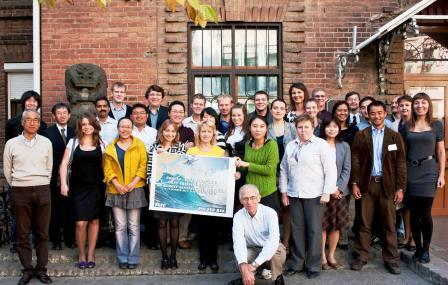
group shot
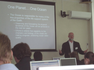
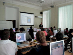
Lecture Data Analysis Exercises with Software
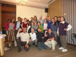
Farewell party on the last day Far Eastern Federal University of Russia


